
|
|
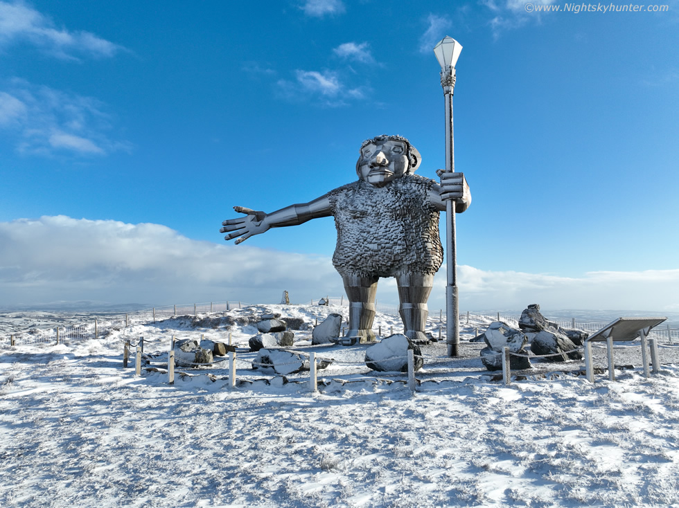 |
It's a brand new year and with it came a five day cold spell thanks to deep Arctic air and Nly flow which brought numerous snow showers across N. Ireland throughout the period. We had snow on the hills every day and at least three days of laying snow at low levels. I wanted to do something different and get 2026 off to a good start so we hiked through Gortin Glen Forest Park outside Omagh on a 7.6km round trip, half of it uphill, and captured the famous Sperrins giant 'Darach' covered in snow and obtained our first ever winter footage of this famous area. This was a great hike, surrounded by snow, crisp clean air, good exercise and a lot of fun. One page report with 26 images and 1 video vlog. - REPORT.
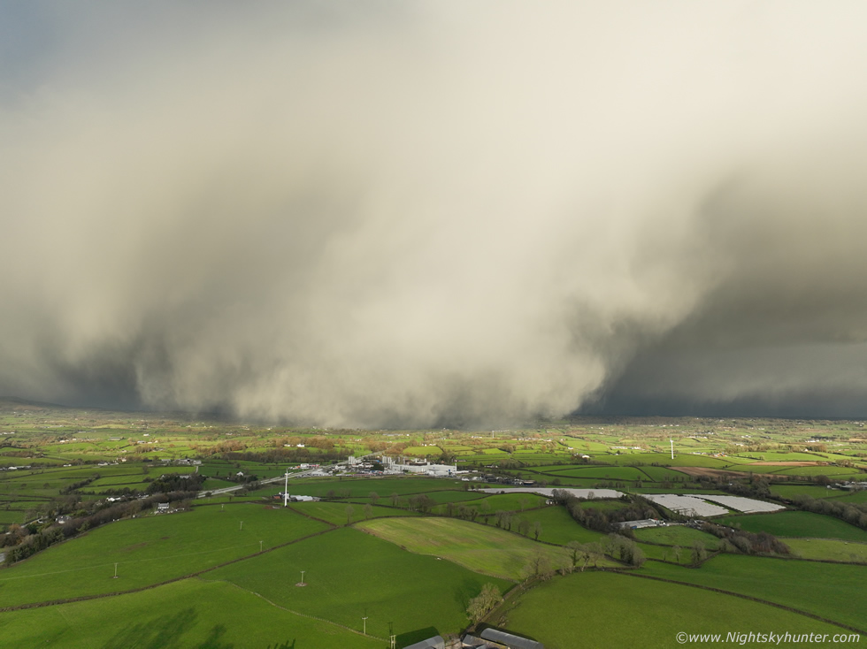 |
On November 19th and 20th 2025 N. Ireland experienced it's first cold spell of the season when polar air would introduce frosty nights, scattered snow showers and two days of yellow warnings. I ended up surprised just how photogenic this two day event turned out to be. I wasn't expecting much on the 19th until two cells approached Moneymore then Cookstown producing the most spectacular snow curtains I've ever seen in my life. The 20th brought several inches of laying snow and beautiful scenes over the Sperrins at Mullaghmore, Eagle's Rock & Birren Road. Two exciting days of drone filming in the first snow of the season. One page report with 31 images and 3 video clips. - REPORT.
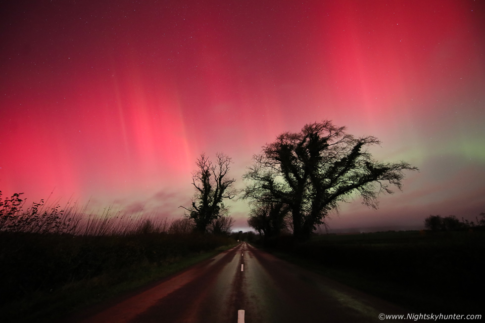 |
I had almost given up on seeing a good aurora this year due to cloud cover. Then on November 11th/12th 2025 two CMEs impacted the Earth's magnetosphere after midnight delivering a severe G4 geomagnetic storm which turned out to be the third strongest of the solar cycle. The sky suddenly cleared so I drove out and by chance found a location near Lissan outside Cookstown. The CME arrived with the Bz diving below -40, the result was a spectacular red aurora. The sky was on fire with reds and pinks punctuated by tall beams dancing aloft, the highlight was standing in the middle of a country road until 4am with crimson rays dancing over the dark outline of a group of trees which resulted in a wonderful photo opportunity. One page report with 20 images. - REPORT.
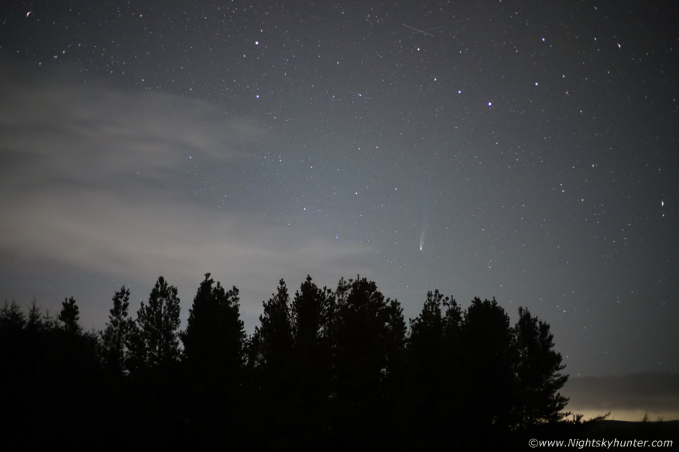 |
October 2025 was the month for comets with several interesting visitors in our skies. However the highlight was C/2025 A6 Lemmon, a long period comet which became much brighter than expected. Original forecasts went for a mag+10 peak however the comet over performed reaching mag +3.5 becoming visible to the naked eye and perfectly placed in our evening skies after dark with the highlight during the moonless period. This report documents several nights battling cloud to see the comet. I ended up impressed, at its peak I observed a 10 degree naked eye tail pointing straight up into the star fields of Corona Borealis. Another highlight was capturing a fireball in the same image as the comet. One page report with 20 images. - REPORT.
 |
Astronomy is not the only subject I'm interested in, check out my N. Ireland Storm Chasing section and view the chase reports and images which detail not only storms but other phenomena such as a moonbows, noctilucent clouds, aurora displays and exciting nature related photo shoots.
Martin McKenna
Home